The seemingly essential chaos of weather and, slightly less so, the climate at-large is enormously undersold. We can say very big things (the planet is warming catastrophically) and we can say relatively small things (it will likely rain somewhere in this geographic area this evening), but in between the situation is opaque as hell. Whether it comes from the National Oceanic and Atmospheric Administration (NOAA) or the Old Farmer's Almanac, statements about six months from now are sketchy, albeit with the latter being orders of magnitude more sketchy than the prior.
Advertisement
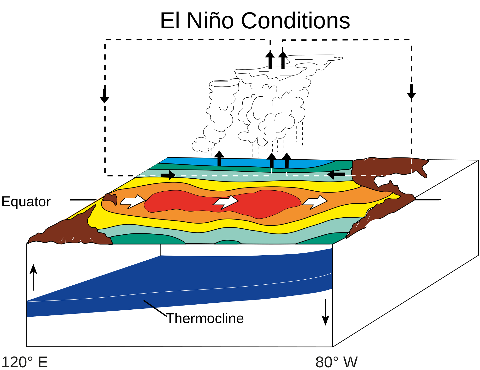
This opaqueness includes El Niño, a recurring pattern of surface warming in the eastern-ish Pacific Ocean. You may have noticed that over the past weeks a great number of people, including some actual authorities, buzzing about a powerful El Niño brewing for this upcoming winter. California will flood! Oregon will burn! Washington D.C. will, uh, do one or the other or maybe just something in the middle, as per a usual year.To be clear, the 2015 El Niño looks like a slam dunk, with NOAA declaring in its July outlook that, "There is a greater than 90 percent chance that El Niño will continue through Northern Hemisphere winter 2015–2016 … with many multi-model averages predicting a strong event …" This is an unusually high probability.El Niño is one of only a couple of climate-scale events that allow us to look at this middle-range of timescales and say much of anything. Hype aside, however, it remains unpredictable even as it seems to materialize. In a commentary published in this week's Nature, NOAA senior scientist MJ McPhaden offers a timely look back at the 2014 El Niño that wasn't, which the NOAA had assigned an 80 percent probability of occurring.In the early months of 2014, a series of large-scale wind bursts occurred over the western equatorial Pacific as abrupt relaxations of the trade winds. The ocean's response to these shifts was remarkably similar to what was seen prior to the 1997-1998 El Niño, the largest on record. That winter saw devastating flooding in California and North Dakota, ice storms in the Northeast, and a rash of tornadoes in Florida.
Advertisement
The recurrence rate of El Niños of that magnitude is thought to be 15 to 20 years, and, in 2014, this meant we were due. Meanwhile, excessive heat was building above the thermocline—the thin body of water separating mixed surface layers from deep cold layers in bodies of water—along the equator. Such an event has preceded every moderate El Niño season through the past 35 years of observations.
So, in June of 2014 NOAA released its prediction: "the chance of El Niño is about 70 percent during the Northern Hemisphere summer and is close to 80 percent during the fall and early winter." Not long after, however, sea surface temperature (SST) anomalies began to decay as the trade winds again gathered steam. Seasonal forecasts decayed with them and, in January 2015, the NOAA predicted that the weak warming that did occur was projected to completely dissipate by spring. Which should have been the end of it."However, the much-ballyhooed El Niño, though moribund, was not completely dead," McPhaden writes. "Surprisingly, it came roaring back with renewed vigour during the first half of 2015, energized by a new spate of strong westerly wind bursts. These episodic wind events, some of which were associated with highly unusual cyclone activity in the western Pacific in early 2015, are a form of stochastic forcing for El Niño."The lingering, albeit mild warmness leftover from 2014 helped trigger cyclone activity, which in turn led "El Niño to rise, phoenix-like, from the ashes," McPhaden says. "This puzzling evolution has generated considerable soul-searching about why El Niño forecasts, as well as expectations based on conventional wisdom, fell so wide of the mark."The 2014 El Niño failed to materialize because atmospheric wind patterns failed to "couple" to the cyclic deep oceanic churning, or convection, that normally works to keep warm surface temperatures on the western side of the Pacific. In an El Niño year, warm surface water should be scooted unusually to the east, bringing storms with it, which then serve to amplify the El Niño itself, helping to hold the warm water in place. The initial trade wind disturbances initiated the process by loosening their hold on the Pacific's usual east-to-west flow, but the process broke down after.There are several possibilities for what happened exactly, but nothing is certain. It may just have been the run of the mill randomness of a highly random process, or the effects of timing, or it may have had to do with unusually warm SSTs in the eastern Indian Ocean. McPhaden's ultimate point is that we need to work harder to understand these interactions."Climate change may plausibly have played a role via warming trends in the Indo-Pacific warm pool, but it will be a challenge to convincingly tease out its possible influence from a broad spectrum of natural variations," he writes.Finally, McPhaden concludes, "Seeking answers for why an erstwhile major El Niño unexpectedly went into hiding in 2014 only to re-appear in early 2015 with renewed intensity is a priority that will provide fertile ground for new research. The stakes are high because seasonal climate variations driven by ocean–atmosphere interactions in the tropical Pacific affect so many people around the globe."
ONE EMAIL. ONE STORY. EVERY WEEK. SIGN UP FOR THE VICE NEWSLETTER.
By signing up, you agree to the Terms of Use and Privacy Policy & to receive electronic communications from Vice Media Group, which may include marketing promotions, advertisements and sponsored content.